CommentsPLATKIN ON PLANNING--LA City Planning will soon be forced to make a clear choice regarding the Purple Line Subway Extension. In particular, City Planning is sponsoring two community meetings, on June 29 and 30, to undertake station area planning for three stations: Wilshire/LaBrea, Wilshire/Fairfax, and Wilshire/LaCienega, shown on the map above.
Which approach to station area planning will prevail?
The fork in the road for both METRO and the City of Los Angeles is the actual purpose of mass transit. Is it to improve the mobility of Los Angeles residents, to give them more appealing transportation options? Or, is the purpose of transit, such as the Purple Line Extension, to create opportunities for real estate investors to capitalize on suddenly valuable parcels at station areas?
While most people assume the purpose of transit is to improve mobility for local residents, commuters, and visitors, the choice facing City Hall, based on clashing precedents, is much murkier. The direction, therefore, that the planners and then the City’s elected officials make, will have repercussions for decades to come, probably, in fact, past the end of the 21st century.
There is a precedent for planning station areas early in the construction process, to make sure that neighborhoods adjacent to transit stations, generally in a quarter-mile radius, are carefully designed to reflect the concerns of both local residents and future passengers. In fact, the Planning Department already prepared comprehensive specific plans for the subway stations at LaBrea/Wilshire and Fairfax/Wilshire, including visionary station designs. City Planning prepared these plans in the early 1980’s, when the original Metro Rail alignment was Wilshire Boulevard to Fairfax, and then north on Fairfax through West Hollywood, Hollywood, and over the Cahuenga Pass to North Hollywood.
METRO, then called the Southern California Rapid Transit District, hired the Department of City Planning to prepare approximately 13 separate Specific Plans. When METRO changed the original alignment in 1986 because of political pressure, two of those completed plans, including their EIRs, now correspond to the new Purple Line Extension stations. They could easily be pulled out of old file cabinets, dusted off, and with a few changes, be brought up-to-date.
But, don’t hold your breath because of a conflicting precedent, Metro’s Expo Lines. In this case, the planning process has strictly focused on up-zoning and up-planning station area parcels to promote Transit Oriented Development, even though METRO itself calls for Transit Oriented Districts/Commununities.
This alternative is called Neighborhood Transit Plans, an ambitious City Planning program to create local plans for stations on all of METRO’s rail projects in Los Angeles. The most advanced of these plans, for the Exposition Line, is a draft specific plan, first unveiled in January 2015, but yet to be adopted. This draft is, in my view, the template for all future Neighborhood Transit Plans, including those for the Purple Line Extension.
A careful look at this template reveals that it is a zoning document. Even though the template is labeled a plan, it is not, tellingly, part of the General Plan. It is, in effect, a plan implementation tool, zoning, that is mislabeled a plan.
There is also a companion Streetscape Plans for each of the Exposition Line’s stations, but these document are not part of the draft Specific Plan. The differences are critical. The City Planning Commission and the City Council adopt Specific Plans as ordinances. Streetscape Plans, however, are only advisory documents that the Board of Public Works, Cultural Affairs Commission, and the City Planning Commission approve. While Streetscape Plans do include detailed improvements for public areas, they have no implementation authority, such as the City’s budget, capital projects, or Departmental work programs.
Basic Steps for Purple Line Station Area Planning
Given these alternative precedents, how should the City of Los Angeles now proceed with comprehensive planning for the Purple Line Extension, as well as other METRO rail corridors?
First, the entire station area planning process should be completed and implemented before the Purple Line opens to the public in 2023. Considering that the Blue Line, Green Line, and Orange Line are operational, but do not yet have any adopted transit station area plans, this is not a good start. Likewise the Red Line subway, between the downtown and North Hollywood, with a Purple Line spur to Wilshire/Western, only has one adopted plan, the Vermont/Western Transit Oriented District Specific Plan (SNAP). This corridor, like other centers in Los Angeles, does, however, have land use plans prepared by the Community Redevelopment Agency. At some future point, these redevelopment plans will be transferred to the Department of City Planning and may become additional specific plans for transit stations.
Second, the station area planning process should not reinvent the wheel. The dormant station plans from the previous rail alignment should be re-used, but with a warning. Those older plans did not view transit as a gift horse to real estate developers, but as a threat to existing communities located near stations. These plans protected existing communities from over-development by subway projects in older Los Angeles neighborhoods. These plans also included a subsequently discarded planning principle: new real estate projects should be limited to the capacity of local infrastructure and services.
Third, instead of using rail projects to attract new residents to station areas, the plans should focus on public improvements that address the mobility needs of existing residents and commuters. This principle is at odds with the model Exposition Specific Plan, whose purpose is to encourage high-density apartment projects, based on the untested assumption that their tenants will live near subway stations and, therefore, use mass transit.
Fourth, the restored station area plans must address heavy automobile traffic generated by the nearby Cedar-Sinai Hospital, Beverly Center, Beverly Connection, Grove Shopping Center, and Farmers Market. These local traffic generators need be carefully linked to the new subway stations.
Fifth, to properly serve the transportation needs of Purple Line Extension neighbors and commuters, the planning process should include the following agencies and projects:
- Bureau of Street Services regarding systematic tree planning, pedestrian curb cuts, and other sidewalk improvement in the station planning areas, at least a 1/4 mile from the station site. The precedent for these improvements can be found at the Purple Line’s Wilshire-Vermont station, where METRO paid for similar improvements on both Vermont and Wilshire Boulevard.
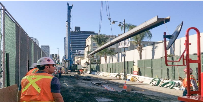
- Department of Water and Power regarding the undergrounding of power utility lines in station areas. Since the relocation of these utility lines is part of subway construction, some of this work is already underway.
- Department of Transportation, regarding the construction of bicycle infrastructure and pedestrian enhancements, such as intersection redesign and way-finding signs.
- Bureau of Street Lighting regarding the installation of improved street lighting on pedestrian-oriented streets.
- METRO regarding the construction of station-site interfaces for cars (Kiss ‘n Ride and Park ‘n Ride), busses, taxis, carpools, vanpools, pedestrians, motorcycles, and bicycles.
- Los Angeles Police Department regarding citations for automobile drivers who block pedestrian crosswalks with their cars.
The combination of these public improvements is called Transit Oriented Communities (TOC) by METRO, so there should be no reluctance on their part to assure that these features are properly planned, funded, and constructed prior to 2023.
Evolution of Station Area Planning in Los Angeles
Underlying this discussion is the steady evolution of station area planning from broad improvements in mobility to now rolling out the red carpet for real estate projects. While the older plans were growth neutral, the current approach is clearly growth inducing, but with little concern for the public services that additional residents will require.
A deeper question is why has the focus of station area planning changed so much during the 30 years between the first Metrorail project and the current one. The answer, I think, is the continued collapse of the post-WWII liberal order in the United States, which gradually became neo-liberalism. From the early 1970s onward, President Lyndon Johnson’s Vietnam War promise to the American public of “guns and butter” could not be kept. The traditional liberal formula of progressive legislation at home (e.g., Social Security, Medicare, Voting Rights Act, EPA) married to a hawkish foreign policy collapsed. Even though the hawkish component quickly resumed, this breakdown included the gradual elimination of many domestic programs, such as the Federal government’s programs for public housing programs and local transportation projects.
To justify these cutbacks in domestic programs, neo-liberal ideology filled the bill nicely. Its main tenant was that market forces, if properly infused by deregulation and incentives to investors, could address stubborn social problems, such as traffic congestion and high priced housing. When applied to cities, neo-liberalism meant the elimination of major urban programs and the deregulation of zoning and environmental review. As a result, local government policies have since then deliberately benefited owners of commercial property, on the assumption that if zoning barriers, such as use, height, density, and parking codes, are removed, developers will build a cornucopia of Transit Oriented Development near transit stations. This miracle cure would simultaneously provide affordable housing and drive up transit ridership. So far this has not yet happened, but its defenders claim they need more time for their zoning plans to be vindicated.
Unfortunately, we do not have enough time for this grand experiment to be played out. The supposed miracle cure of high density market housing built at subway stations, regardless of population trends or the capacity of public infrastructure and services, will lock us in to undesirable land use patterns that will haunt us for generations to come. Affluent residents in these areas are not likely to become regular transit users, while local streets, parking facilities, and other public services will not be able to keep up with increased user demand.
This is why I have argued that the focus of station area plans should be public improvements, such as better sidewalks, not up-zoning and up-planning handouts for real estate tycoons.
It is also why I now argue that the planning for the Purple Line stations forces the Department of City Planning to make some tough choices on the ultimate purpose of mass transit. Will it be the needs of residents and commuters or will it be the needs of real estate speculators?
(Dick Platkin is a former LA city planner who reports on local planning issues for CityWatch. He welcomes comments and corrections at [email protected].)
-cw
Metro’s Purple Line Meets a Fork in the Road
Typography
- Smaller Small Medium Big Bigger
- Default Helvetica Segoe Georgia Times
- Reading Mode